THE DISASTER THAT SHOOK A CONTINENT
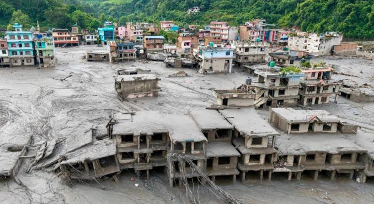
On the morning of 26 August 2026, at approximately 8:37 AM Nepal time, a massive section of glacier and bedrock collapsed from high in the Langtang Himal, near the Nepal–Tibet border at over 5,200 metres elevation. The impact registered as a magnitude‑5.2 earthquake on seismic instruments — so vast that monitors initially mistook it for tectonic activity. An ice‑rock debris mass plunged into the valley, blocking the Bhote Koshi River and forming an instant natural dam. When that dam breached roughly 24 hours later, it unleashed a terrifying wall of water, mud, boulders and ice that tore down the Bhote Koshi and Trishuli corridors at speeds exceeding 50 km/h.
By 1 September 2026, the confirmed death toll had reached 1,003 people, with more than 4,400 still missing — including locals, Indian pilgrims, and trekkers from at least 33 countries. Entire villages were swept away; 32 bridges vanished along a 42‑kilometre stretch; customs facilities at the Rasuwagadhi border crossing were obliterated; and an estimated 748 megawatts of hydropower capacity — nearly 40% of Nepal’s installed generation — was destroyed or severely damaged. Eighteen schools were fully destroyed and 20 more damaged, leaving approximately 10,000 children affected. The disaster has been described as one of Nepal’s deadliest in living memory.
NEPAL: THE WATER TOWER OF SOUTH ASIA
The tragedy is far more than a local catastrophe. Nepal sits at the hydrographic heart of the subcontinent. Its three great river systems — the Koshi, Gandaki and Karnali — drain south from the Himalayas to feed the Ganges, the river that sustains civilisation across northern India, Nepal and Bangladesh. The Ganges‑Brahmaputra‑Meghna basin supports at least 630 million people, with the Ganges basin alone spanning 1.09 million square kilometres across four nations. Nepal contributes roughly 13% of the Ganges basin area — but its rivers deliver a vastly disproportionate share of the water, especially during the critical dry season.
During the dry months — when monsoon rains have long since vanished — up to 75% of river flow in the Ganges system comes from Himalayan snow and glacier melt, the vast majority passing through Nepal. These mountains act as Asia’s frozen water bank: accumulating snow and ice through winter, releasing it steadily through spring and summer to keep rivers flowing, farms irrigated, and taps running across the plains. For nearly 1.6 billion people across South Asia, Himalayan meltwater is not a scenic extra — it is the difference between water security and chronic scarcity.
THE DOUBLE CRISIS: TOO MUCH WATER, THEN TOO LITTLE
Scientists warn that the 26 August flood is a terrifying preview of what climate change is doing to South Asia’s water foundations. The crisis unfolds in two devastating phases:
Phase One: Unstable Glaciers = Deadly Floods
As global temperatures rise, Himalayan glaciers are thinning, retreating and fragmenting at accelerating rates. This creates two lethal hazards: glacier collapses (such as triggered the August 2026 disaster) and Glacial Lake Outburst Floods (GLOFs) — when meltwater lakes formed atop retreating glaciers breach their unstable earthen dams.
- ICIMOD, the regional mountain research authority, has identified over 8,000 glacial lakes across the Hindu Kush Himalaya. Of these, roughly 200 are classified as potentially dangerous across the wider region.
- Within Nepal specifically, 47 high‑risk glacial lakes have been identified across the Kosi, Gandaki and Karnali basins — 25 of which lie across the border in Tibet, directly upstream of Nepal’s rivers.
- The frequency is accelerating: Nepal has recorded at least 14 major GLOF or glacier‑related flood events in recent decades, with three occurring in just the past two years — Thame (2024), Tilgaon (May 2025), and now the Bhote Koshi disaster (August 2026). Even tiny lakes — as small as 0.016 square kilometres — have unleashed floods that travelled 35 kilometres downstream, destroying infrastructure.
Phase Two: Once Glaciers Are Gone, WATER SCARCITY FOLLOWS
Even more alarming than the floods is what comes after. For the next 20–30 years, shrinking glaciers will release more water than normal — temporarily boosting river flows while causing repeated disasters. But once the glaciers shrink past a critical threshold, their contribution will plummet.
Hydrological modelling from the Langtang basin — just kilometres from where the August disaster struck — projects that by the 2040s, glacier and snowmelt contribution to river flow will fall to just 50% of current levels. A temperature rise of 2°C — widely projected this century — would initially boost runoff by roughly 32%, but once ice volume is depleted, flows will drop sharply, especially in the dry season.
That means:
- Dry‑season river flows across the Ganges basin could decline by 30–40% by mid‑century, according to multiple independent projections.
- Irrigation water for 200 million hectares of farmland — feeding hundreds of millions — will become scarce exactly when demand peaks.
- Hydropower potential will become unpredictable and unreliable, threatening energy plans across Nepal, India and Bangladesh.
- Drinking water security for hundreds of cities — including Delhi, Kolkata, Dhaka and Kathmandu — will be compromised when river levels fall and saltwater intrudes further upstream from the Bay of Bengal.
THE FAILURE: NO SHARED EARLY WARNING, NO JOINT PLAN
Perhaps most damning of all: despite the risks being known for decades, South Asia still operates without a fully integrated, real‑time transboundary early warning system. Data gaps, political mistrust, competing national interests and outdated technology mean that when disaster strikes, warnings are fragmented, delayed or never shared at all. The August flood gave downstream communities barely 20 minutes of advance notice — far too little to evacuate.
ICIMOD and the UN have repeatedly warned that glaciers and glacial lakes know no borders — yet water governance remains strictly national, with no shared monitoring network, no unified risk registry, and no coordinated investment plan for the inevitable water decline.
The August 2026 catastrophe is not a one‑off tragedy. It is a wake‑up call for the entire region. South Asia’s leaders must:
- Build a fully shared, real‑time Himalayan early warning system — monitoring every major glacial lake and upstream river gauge, with data instantly available to Nepal, India, China, Bangladesh and Bhutan, without restriction.
- Map and mitigate every high‑risk glacial lake — deploying sensors, spillway engineering and emergency evacuation routes for the 200+ lakes that could burst at any moment.
- Plan now for water decline — invest in water storage, drip irrigation, crop diversification and urban efficiency before river flows drop. The World Bank estimates that even developing all proposed dams in Nepal would add only 130–145 billion cubic metres of storage — barely enough to offset the meltwater decline that is coming.
The floods that tore through Nepal on 26 August killed over a thousand people and left thousands more missing. But they also revealed something far bigger: the water tower of Asia is breaking apart. First it will unleash floods — more frequent, larger, deadlier. Then it will run dry.
For 1.6 billion people across South Asia, the message is clear: the water that sustains your cities, your farms, your electricity and your children comes from melting ice in the Himalayas. That ice is vanishing — faster than anyone predicted — and once it is gone, there is no replacing it.
The question is not whether South Asia will face a water crisis. The question is whether its governments will co‑operate to prevent it — or wait until the rivers run low and the conflicts begin. The warning from Nepal has been delivered. The time to act is already running out.